Project Logo

Consultation Website

  • Home
  • Welcome
  • About The Site
  • Our Vision
  • Our Proposals
  • Interactive Map
  • Technical Delivery
  • Sustainability
  • Application And Timeline
  • FAQs
  • Useful Links
  • Submit Your Feedback
  • About Us

Welcome

Thank you for visiting our consultation website to find out more about our proposals.

We are preparing an outline planning application for new homes and public open space on Land Off Grove Road And Bulbourne Road, Tring.

Our vision is to plan a high quality, sustainable and well connected development providing a range of house types and sizes, including much needed affordable housing.

This website provides an overview of the emerging proposals and design.

It also provides an opportunity for you to share your comments on the outline scheme as part of the pre-application consultation, ahead of us submitting an outline planning application to Dacorum Borough Council (DBC) later in the process.


New Home Delivery

The Government published a new National Planning Policy Framework (NPPF) in August 2026, which continues to support its ambition to deliver 1.5 million new homes and ensure that local authorities plan positively to meet their housing needs.

The NPPF requires local authorities to use the Government's standard method for assessing local housing need, and they are also required to maintain a minimum five-year supply of deliverable housing sites against their identified housing requirements.

These proposals are therefore being brought forward to help meet identified housing needs and contribute towards the delivery of new homes.


The Local Plan

This site is identified in the draft Dacorum Borough Council (DBC) Local Plan to 2041.

The site considered suitable for residential development, with an allocation of approximately 400 homes (Site reference Tr02).

Although it is currently designated as Green Belt, the draft plan proposes its removal from this designation to enable development.

The Local Plan has reached examination stage and is awaiting the Inspector’s Report.

This site adjoins another draft allocation (Site reference Tr03 land East of Tring), located to the east of the site boundary, which is intended to accommodate up to 1,400 homes and a range of facilities.

Tr03 has had two hybrid planning applications (references 22/01187/MOA and 25/01880/MOA) refused, most recently in April 2026.  Although there is no live planning application, Land East of Tring remains a draft allocation in the Councils Local Plan

DBC Logo

About The Site

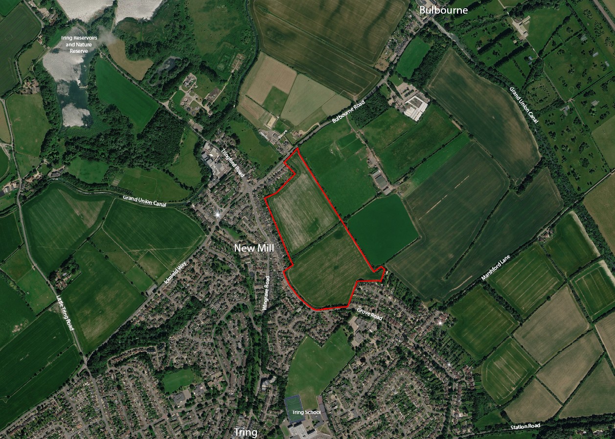
This 14.7 hectare site lies on the northern edge of Tring within the Tring Gap Foothills, with Bulbourne Road bordering the site to the north.

The site consists of two field parcels separated by mature boundary vegetation, including hedgerows and trees.

It is bounded to the west by existing residential development along Wingrave Road and Grove Road, with further housing to the south and agricultural land to the east (which forms part of the draft allocation Tr03 in the DBC Local Plan).

The site sits approximately 1.5km from Tring Town Centre, which provides a range of local amenities, including shops, restaurants and educational facilities. 

Tring Railway Station is located approximately 2km to the south south-east of the site.

Grey Belt Land

The site is to be considered a Grey Belt site, The term Grey Belt is used to describe land within the designated Green Belt that is considered to have a lower environmental, landscape or strategic value.

This can include land that is previously developed, visually contained, or less connected to the wider countryside.


Our Vision

We aim to deliver a diverse range of new homes, including affordable housing, all designed to meet high sustainability standards. The development will be set within attractive green spaces and well connected to existing local facilities and services.

The landscaped spaces that surround the proposed new homes provide a variety of open spaces, including formal and informal green space, for recreation and for nature. 

Existing trees and hedgerows will be retained where possible, and enhanced through new planting to strengthen the existing natural features of the site.

Areas have also been incorporated through the site to provide space for play and recreation as part of encouraging healthy and active lifestyle

The following sections outline the emerging proposals in more detail.

We encourage you to share your views using the online feedback survey in the SUBMIT YOUR FEEDBACK section of the website.

New Homes
Affordable Housing
Extensive Public Open Space
Walking and Cycling

📷

Our Proposals

The development of the site on Land Off Grove Road And Bulbourne Road, Tring would create a desirable and sustainable new neighbourhood that supports the health and well-being of residents.

The proposed development will be brought forward through an Outline Planning Application With All Matters Reserved (excluding access) to the Council.

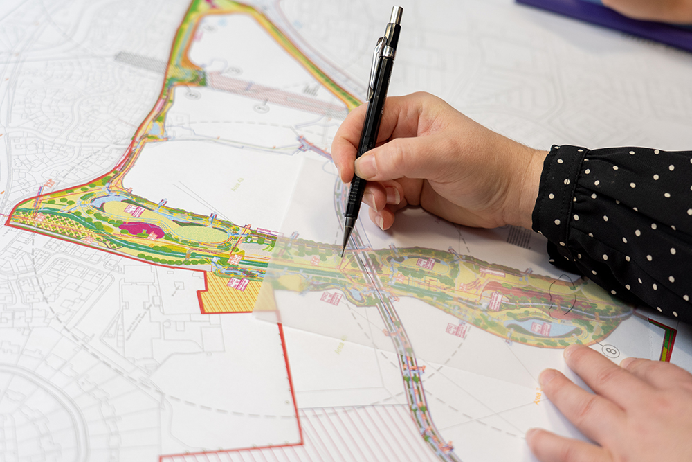
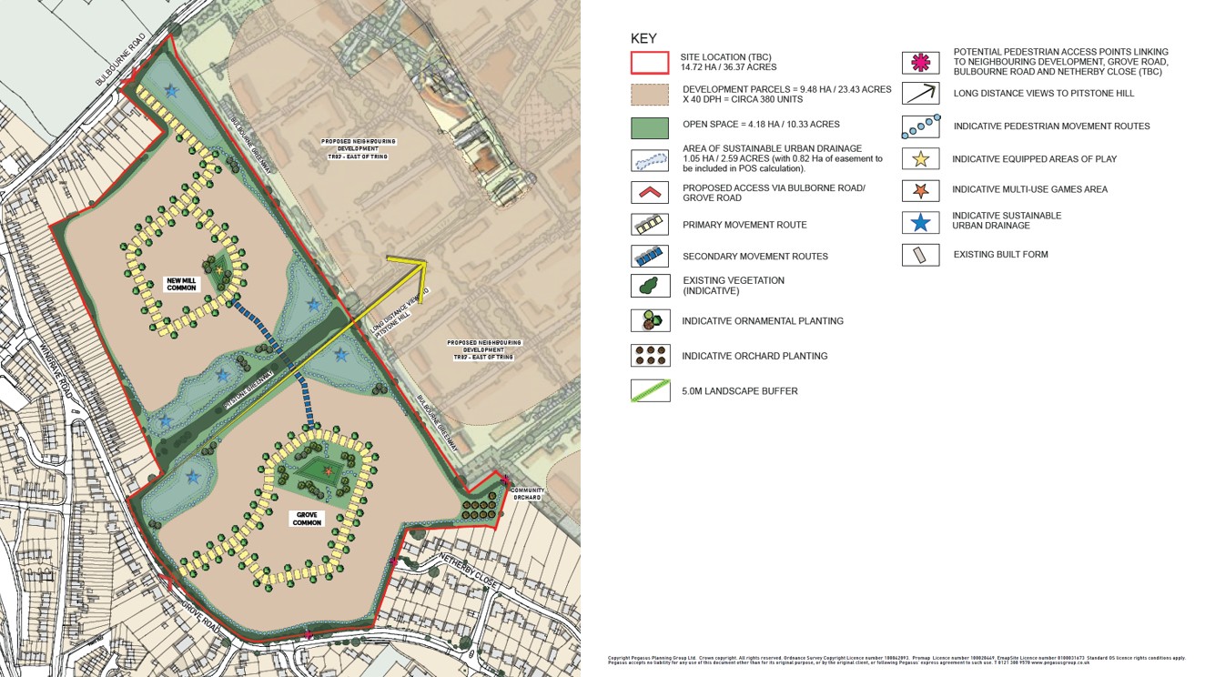
We have produced an Initial Concept Plan which establishes key principles for the delivery of the new neighbourhood in line with the vision. 

In summary the proposals provide:

  • Up to 400 new homes
  • Minimum 40% affordable housing (i.e. a minimum of 160 affordable homes)
  • Over 25% of the site (10.3 acres) will be public open space with community orchards and children’s play areas including a multi-use games area
  • Network of new pedestrian and cycle routes 
Draft Masterplan

Interactive Map

This interactive map provides an opportunity to share your thoughts on our proposals for new homes.

Simply click on the map to explore the site, and use the zoom features (+ and - buttons) to see the key features.  You can click on an area to leave a comment directly on a specific location or feature that matters most to you.

Your feedback will help us understand local priorities and shape the plans to better reflect the needs of the community.

All comments submitted relating to the proposals below will be reviewed before publication.  Sorry any content containing offensive or abusive language will not be published.

We aim to publish approved submissions within five working days of receipt.

For the best user experience, view this interactive map on a desktop computer.

Technical Delivery

As part of our proposals, we work with specialist consultants to carefully assess the site and make sure it can be technically delivered.

This includes looking at things like drainage, ecology and highways.

Highways And Access
Ecology
Archaeology And Heritage
Flooding And Drainage
Air Quality

📷

Sustainability

New and existing homes account for 20% of greenhouse gas emissions in the UK.

Building sustainability is a key feature of delivering new homes.

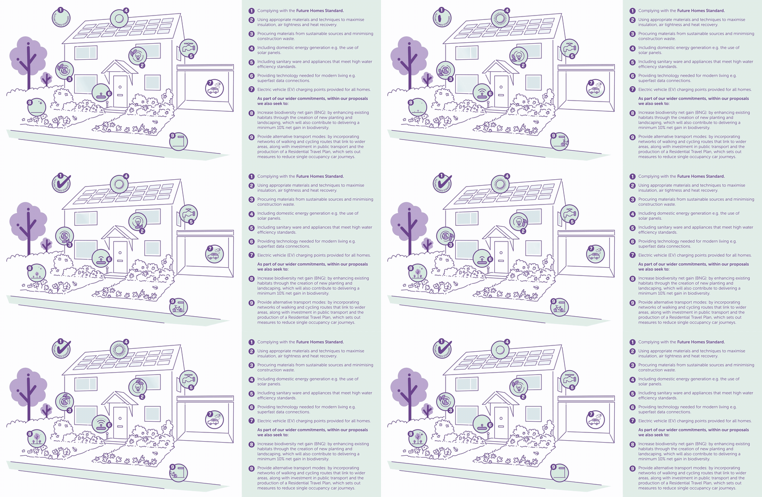
The final design of the new homes would be submitted at a later date, should outline planning permission be granted, however, the broad principles for sustainability are outlined below:

Application And Timeline

We will be submitting an Outline Planning Application With All Matters Reserved (excluding access).

Outline Planning Applications seek to establish whether the scale and nature of a proposed development would be acceptable to the Local Planning Authority, before a fully detailed proposal is put forward.

Where outline permission has been granted, an application for the outstanding Reserved Matters can be submitted.

This will typically include information about the layout, landscape and appearance of the development.

Statutory consultees (eg. Environment Agency, Highways England, Natural England and Parish Councils) and local residents will also have the opportunity to formally comment on our application once submitted and registered with the Council.

The diagram below sets out an approximate timetable starting from this consultation period.

Should planning permission be granted
Consultation: Autumn 2026
Planning application submission: Winter 2026/2027
Planning committee determination: Summer 2027
Should planning permission be granted
Sale to housebuilder or developer: Summer 2028
Reserved Matters submitted by Housebuilder or Developer: Autumn 2028

FAQs

Whether you’re curious about how land promotion works, want to know what to expect during the planning stages, or are simply exploring more about the proposals this section is designed to provide simple and transparent information to questions commonly raised.

Submit Your Feedback

To help us better understand your views, please submit your feedback via our online survey. 

Click on the SUBMIT YOUR FEEDBACK BUTTON.

We also accept feedback via email: feedback@catesbyestates.co.uk or via post (no stamp required) with the address freepost: CATESBY ESTATES.

Consultation closes SUNDAY 4TH OCTOBER 2026.

About Us

Catesby Estates is highly regarded as one of the foremost experts in strategic land promotion and infrastructure delivery.

Landowners choose to partner with us as their strategic land promoter, due to our track record in successfully delivering planning consents and our ability to maximise land value.

We use our in-house expertise and financial resources at no cost to the landowner, to promote land through the planning system with the aim of obtaining planning consent.

The land is then marketed to our extensive network of housebuilder and developer contacts.

The land site is sold with the aim of maximising value for the landowners.


A land promoter focuses on securing planning permission for land and then selling it on without doing any construction or housebuilding.

A housebuilder or developer buys land (often with outline planning permission already in place) and builds the homes.

Housebuilders like land promoters because promoters take on the costly, risky, and time-consuming process of securing planning permission.

This means builders can buy “oven-ready” sites with approvals in place, saving them uncertainty and allowing them to focus on what they do best, which is delivering and selling homes.